Water and sewer network modelling, in the cloud.
The cloud platform for water and sewer network modelling.
HydroDSS is a fully web-based modelling platform for water and sewer networks — every simulation runs on cloud compute.
- Model on a shared map, from anywhere — no desktop install, no per-seat tokens.
- Transient surge, fire flow, criticality, sensitivity, Monte-Carlo uncertainty — built in, not paid add-ons.
- Import your models, or build from GIS layers.
- hydroData and hydroSpec built in — fetchable geospatial datasets and cited component specs.
- Asset register, risk, and renewals included — every output traceable and auditable.
Free plan, no payment details required. Sign in with a passkey or an email link.
From your model to a renewals plan.
One path, in one platform — bring your network in, model it in the cloud, and turn the result into prioritised renewals.
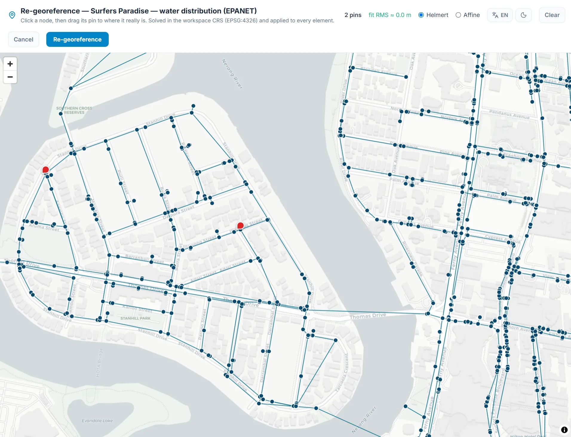
Bring your model with you — import from EPANET or the GIS formats you already use, then georeference it onto the map.
One platform for the whole network.
Distribution and sewer modelling in the cloud, model migration from the tools you use today, an advanced analysis suite, and risk and renewals built in — live on app.hydrodss.com now.
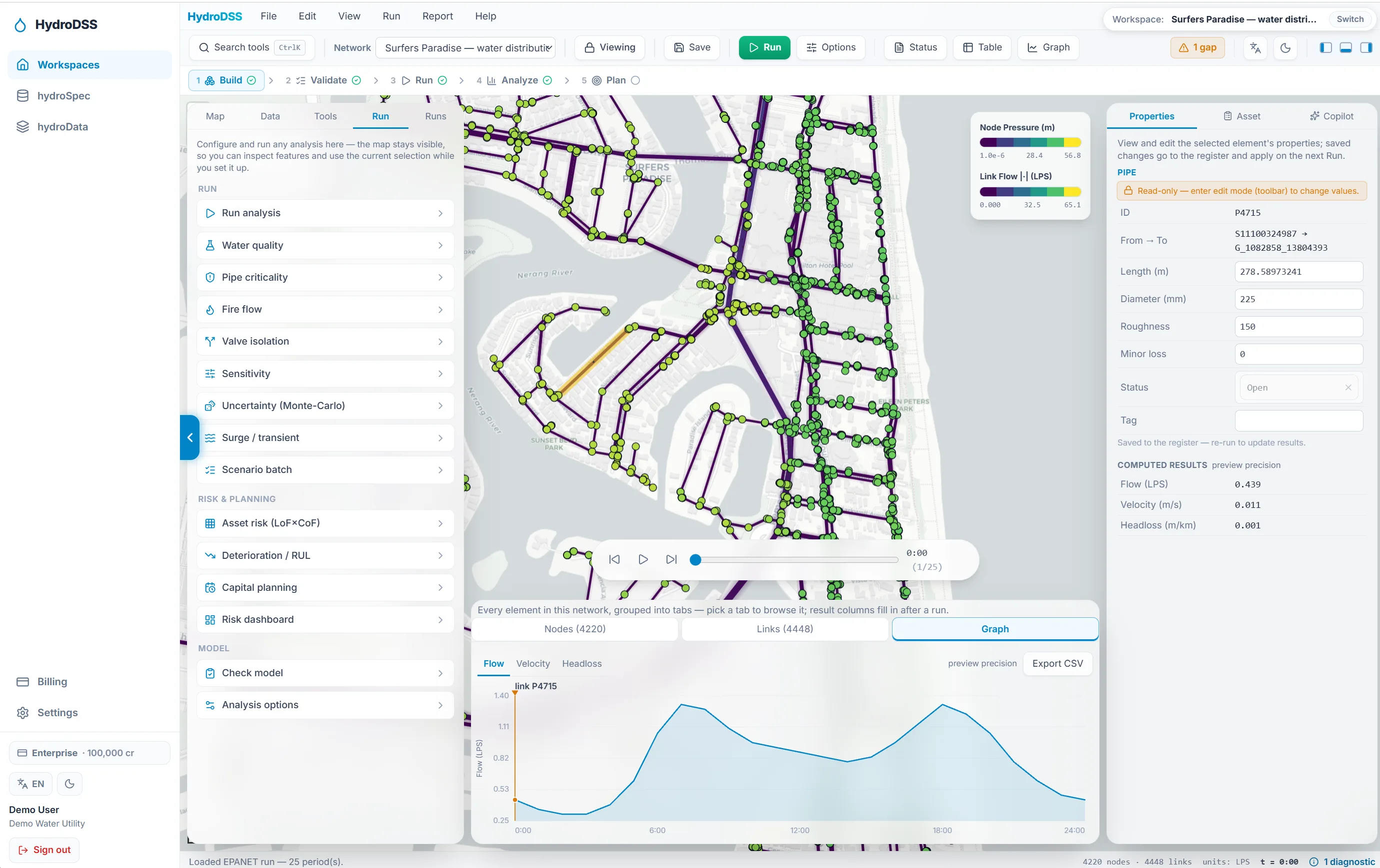
Model the pressurised network.
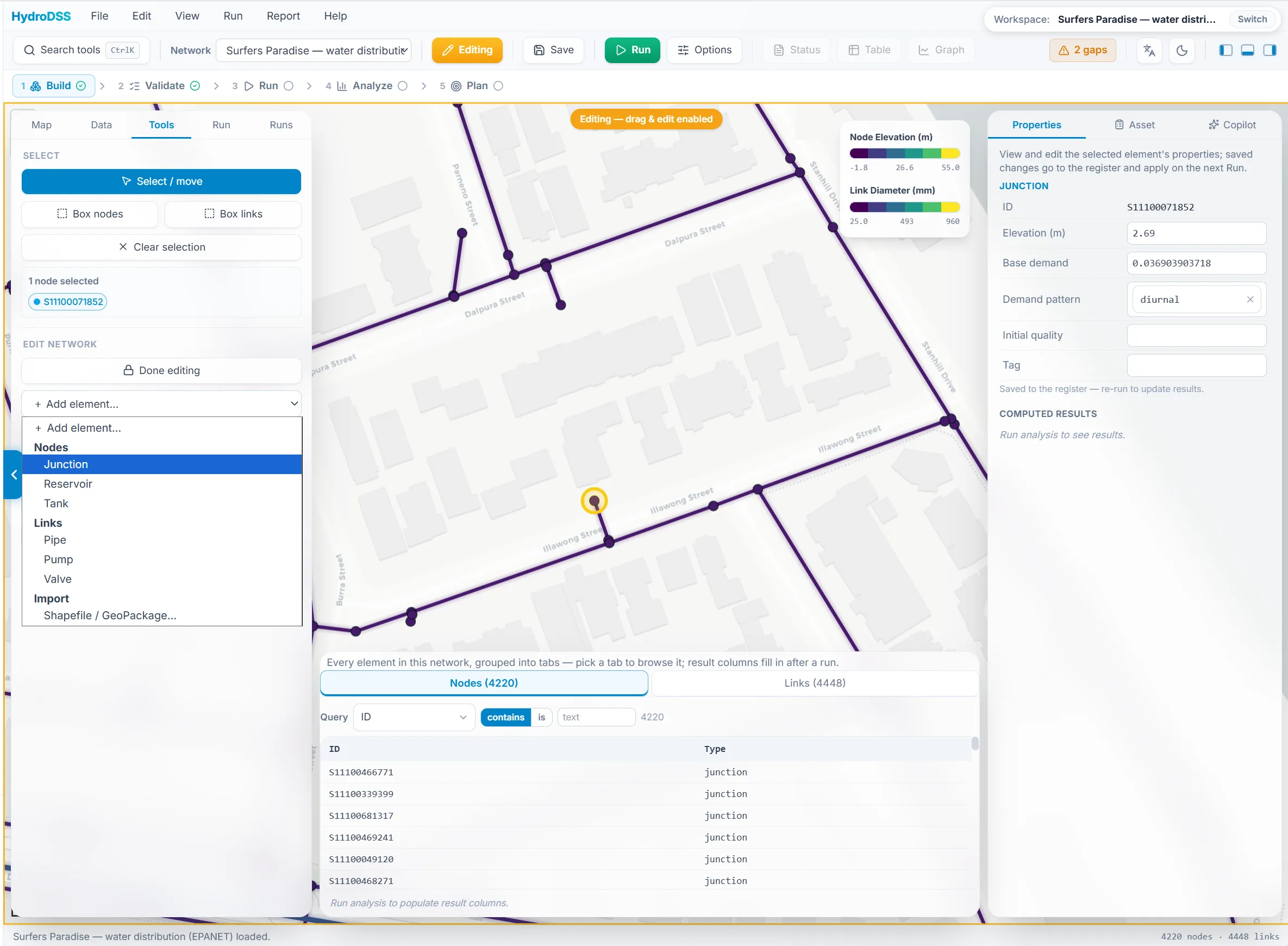
The full distribution network — pumps, valves, tanks, controls, extended-period simulation, and complete transient surge support. Build, import, edit, and run from anywhere, fully web-based; simulations execute on the EPA-reference EPANET engine on cloud compute. No desktop install, no per-seat licence.
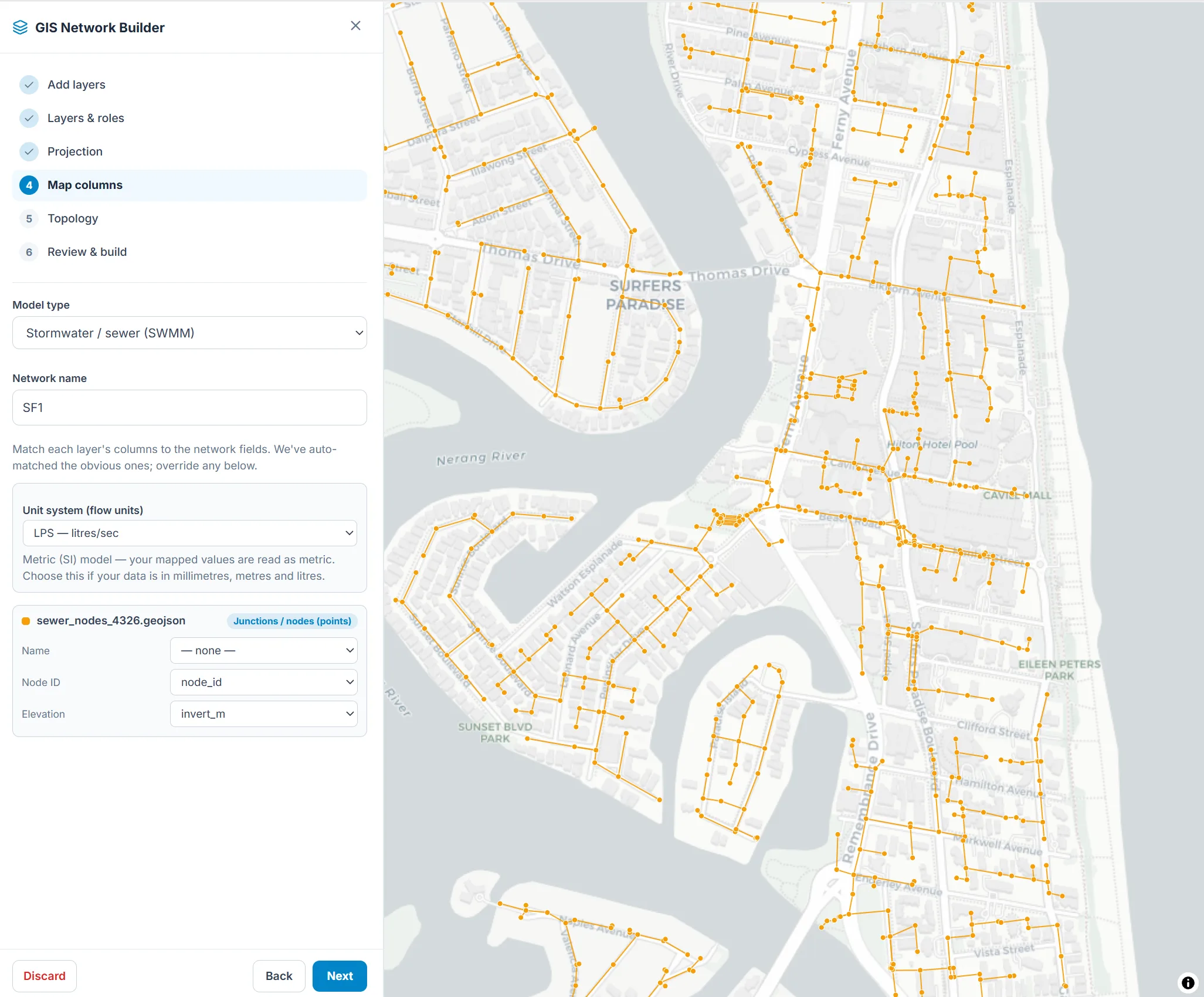
Model the gravity network too.
Sewer and stormwater in the same workspace as distribution — rainfall-runoff, 1D routing, and design-storm capacity screening, on the EPA-reference SWMM engine. One platform for the whole network instead of a separate desktop tool per domain.
Browser-native, multi-tenant, on the map.
A PostGIS asset register as the system of record, a MapLibre GIS view, organisation auth with row-level tenancy. Your model lives in the cloud — versioned, shareable, georeferenced — not in a file on one engineer's laptop.
Bring your existing model with you.
EPANET .inp imports with a lossless round-trip. GIS layers — Esri shapefiles, GeoPackage, GeoJSON, KML, any GDAL vector format — become junctions, pipes, and subcatchments, with two- or three-point georeferencing (Helmert or affine) to place a schematic network on the real map. Migrating from InfoWorks or another desktop tool? Talk to us about bringing your model across — hello@hydrodss.com.
Stress the network before reality does.
Transient surge envelopes (method of characteristics, on the trusted TSNet solver), available fire flow, pipe criticality, Morris and Sobol sensitivity, Monte-Carlo uncertainty bands, design-storm flood capacity, and valve-isolation segments. Each run is metered on the compute it actually uses, and the estimate is shown before you commit a credit.
Find what fails first.
A configurable likelihood × consequence (LoF × CoF) risk matrix with Business Risk Exposure in dollars — built on pipe criticality read from the native hydraulic model — plus deterioration modelling and budget-constrained renewal planning. Every score traceable to its factors.
Live means available on app.hydrodss.com today. Modelling, import, and base runs are on every plan, including Free; the advanced analysis suite and the asset risk layer ship with Pro and Premium.
The engine, the data, and the surfaces you work in.
Five parts give the platform its edge: a differentiable engine that makes calibration a solve, the national-scale data that grounds every model, a cited spec catalog that fills component parameters, a unified register that holds the whole network, and the risk layer that turns it all into a renewals plan.
hydroEngine
One differentiable engine for both domains. The water side is validated against EPANET on the benchmark corpus, with a native transient solver landed; the sewer/stormwater side is in active development. It makes auto-calibration and design optimisation gradient-based — and it is productizing into the platform, not yet its production solver.
Explore the engine → The dataFoundation
National-scale cadastral, location, environmental, climate, and regulatory data — fused with live Earth observation (Google Earth Engine, Sentinel-1, ERA5, NISAR). Already in production via ZoneDSS and AuditDSS; in the app, the hydroData catalog puts fetchable geospatial datasets a click from your model.
See the Foundation → The specsSpec catalog
A provenance-tracked reference library — 3,148 cited specifications, coefficients, and design values across 32 datasets: dimensioned pipe specs by material and DN, pumps, valves, stormwater hydrology, and transient reference data. Every value carries its source. It auto-populates model parameters so engineers don't hand-key them.
Open the catalog → The registerAsset management
One georeferenced register for water and sewer — the system of record the models run on and the risk layer scores against. Parameters auto-populate from the spec catalog; condition feeds back into the hydraulics.
Explore asset management → The risk layerAsset risk
Likelihood × consequence becomes a criticality index and a defensible renewals plan. The pipe-criticality overlay — the first risk surface — runs on the model today.
Explore asset risk →The engine, the register, and the risk layer are separate concerns. The engine answers what the network is doing physically; asset risk ranks what to renew first. The one piece we hold back is the real-time, self-correcting Bayesian twin — our hydroBAG research line — which stays on the roadmap, held to a research bar, while the modelling platform stands on its own.
Grounded in the data that actually drives risk.
The platform is grounded in named, authoritative data sources — already in production on QuestFeed's stack, already powering decisions in ZoneDSS and AuditDSS.
Live Google Earth Engine pipelines keep the foundation current: ERA5 climate reanalysis, JRC global surface-water dynamics, MODIS evapotranspiration, SMAP soil moisture, BoM gridded precipitation, and active-radar Earth observation (Sentinel-1, ALOS-2, NISAR). Every dataset is used as the agency publishes it — so every value traces back to a named, citable source (BoM, ECMWF, NASA, ESA, JRC, Geoscience Australia, ABS), not an in-house model.
Coverage: NSW · QLD · VIC in production (Australia) · New York City & San Francisco in production (United States). New Zealand, UK, and EU on roadmap; regulatory corpus already global across 21 jurisdictions.
The water vertical of an infrastructure-intelligence platform that already exists.
HydroDSS doesn't start from zero. It inherits the same multi-jurisdictional data engineering and the same governed RDS-backed delivery stack that already powers two production QuestFeed products — applied to a standalone water and sewer modelling platform.
ZoneDSS
Live across NSW, QLD, and VIC, plus New York City and San Francisco. Planning intelligence on 12M+ lots and parcels — complete NSW LEP / SEPP / DCP coverage, QLD state planning policies, Victorian planning schemes, and US zoning for NYC and SF.
AuditDSS
In production. 320 regulatory corpora across 21 jurisdictions modelled as a Bayesian-evidence graph — 13K rules, 147K obligations, 67K conditional-probability tables, 2K enforcement actions.
HydroDSS
Live now. The cloud platform for water and sewer network modelling — distribution and sewer engines, a unified asset register, and a GIS, on the same data spine.
Simple, transparent, published.
No quotes to chase. Every plan and every number is on the pricing page, and compute is metered in credits — you see the estimate before a run spends anything.
$0
forever
1 workspace · networks to 300 nodes · 50 credits a month. Model, import, validate, and run.
$1,500/yr
or $150/mo
10 workspaces · 50,000 nodes · 2,000 credits a month · full analysis suite · asset register, risk & renewals.
$5,600/yr
or $560/mo
25 workspaces · 100,000 nodes · 8,000 credits a month · everything in Pro at firm scale.
Custom
by arrangement
Custom limits, credit pools, and terms for utility-scale deployments.
Prices are in USD and exclude tax. Australian customers are charged 10% GST at checkout. Annual billing saves about two months against monthly.
One platform, the whole water network.
Here is the build order. Transient and surge already shipped this way — the trusted TSNet solver, brought to the cloud — and the Earth-observation data layer is live in the app. Floodplain and groundwater follow the same pattern with HEC-RAS (USACE) and MODFLOW 6 (USGS), coupled into one asset and model graph rather than re-inventing the physics. Each item is labelled by where it actually is.
- Live
- In development
- Roadmap
- In research
Earth observation & geospatial data
the hydroData catalog
Live in the app today: 60+ fetchable datasets across 16 families — elevation and DEMs, rainfall and design storms, land cover, soil, satellite imagery and spectral indices, streamflow and station observations — processed into cited model inputs. Next: DEM-driven delineation and auto model-build on the same data layer.
Floodplain mapping
HEC-RAS (USACE) coupled to SWMM
Two-dimensional inundation by coupling the gravity network to the trusted HEC-RAS solver. Brought to the cloud and joined to the same asset and model graph.
Groundwater
MODFLOW 6 (USGS)
Standalone groundwater modelling and SWMM↔groundwater coupling on the trusted MODFLOW 6 solver — the subsurface half of the water cycle.
Dam & reservoir monitoring
satellite
Satellite monitoring of reservoirs and basins. Monitoring only — never dam-safety assurance.
Sewer condition AI
CCTV defect detection
Defect detection from inspection video, scored against likelihood and criticality to drive renewals — the condition input to the hydraulic and risk models.
Real-time & SCADA assimilation
research
Assimilating live telemetry to localise leaks and bursts. Held to a research bar — it must beat a plain baseline before it ships. No self-correcting-twin claims.
This is the direction, not a delivery commitment. The differentiable advantage is specific to distribution hydraulics; the wrapped solvers are named, trusted, public-domain tools we bring to the cloud and couple together — not a claim to out-physics the desktop incumbents.
Common questions.
- What is HydroDSS?
- HydroDSS is a fully web-based cloud platform for water and sewer network modelling. It covers the full stack — distribution and sewer/stormwater hydraulics on the EPA-reference EPANET and SWMM engines, plus transient surge, fire-flow, criticality, and Monte-Carlo analysis on metered cloud compute — and turns the result into asset risk and renewals. Import your existing model as EPANET .inp or GIS layers. It is live now: sign up free at app.hydrodss.com.
- Is HydroDSS available yet?
- Yes. HydroDSS is live. Create a free account at app.hydrodss.com — no payment details required — build or import a network, and run it on cloud compute. Upgrade to Pro or Premium for larger networks, the advanced analysis suite, and asset risk and renewals.
- How much does HydroDSS cost?
- Free is $0 forever: one workspace, networks to 300 nodes, and 50 compute credits a month. Pro is $1,500 per year (or $150 monthly): 10 workspaces, networks to 50,000 nodes, 2,000 credits a month, the full analysis suite, and the asset register with risk and renewal planning. Premium is $5,600 per year (or $560 monthly): 25 workspaces, networks to 100,000 nodes, and 8,000 credits a month. Enterprise is by arrangement. Compute is metered in credits against what a run actually consumes, the estimate is shown before anything is charged, and extra credits come in pre-paid packs from $25. Prices are in USD and exclude tax.
- Does HydroDSS replace EPANET or InfoWorks?
- HydroDSS runs the EPA-reference engines with EPANET 2.3.5 parity and reads your EPANET .inp losslessly, so an existing EPANET model comes straight in — and the platform adds what desktop users usually pay extra for: transient surge, criticality, sensitivity, Monte-Carlo uncertainty, and asset risk and renewals. It is a migration path, not a fight with the incumbents. If you are coming from InfoWorks or another desktop tool, write to hello@hydrodss.com and we will help bring your model across.
- What can I import into HydroDSS?
- EPANET .inp files (lossless round-trip) and GIS layers — Esri shapefile, GeoPackage, GeoJSON, KML, and any GDAL vector format — which become junctions, pipes, and subcatchments. A schematic or unknown-CRS network can be placed on the real map with two- or three-point georeferencing (Helmert or affine). Migrating from another desktop modelling tool? Talk to us at hello@hydrodss.com.
- What is the differentiable hydraulic engine?
- hydroEngine is our differentiable simulation engine, spanning both domains. The water side is validated against EPANET 2.3.5 on the benchmark corpus and has landed a native transient (water-hammer) solver; a SWMM-class sewer and stormwater engine — runoff, infiltration, groundwater — is in active development on the same platform. Because it is differentiable end to end, calibration of roughness, demand, and leakage becomes a gradient-based solve rather than manual trial and error. It is productizing into the platform; the app's production runs execute on the EPA EPANET and SWMM engines today.
- How does HydroDSS handle asset risk?
- Asset risk is a configurable likelihood × consequence (LoF × CoF) matrix scored on your own network. Consequence is read from the native hydraulic model — pipe criticality plus who is affected — so there is no second hydraulic licence to run and reconcile. Risk reads as a banded score and, where consequence is priced, as Business Risk Exposure in dollars, with per-factor explainability, feeding deterioration modelling and a budget-constrained renewals plan. The asset register, risk matrix, and renewal planning ship in the Pro and Premium plans. ISO 31000 / AWWA J100 framing.
- Who builds HydroDSS?
- HydroDSS is built by Dr. Ali Ershadi and QuestFeed Pty Ltd, an Australian infrastructure-intelligence company that also runs ZoneDSS (planning intelligence) and AuditDSS (regulatory intelligence) in production.
Run your network on HydroDSS today.
Sign up free — no payment details required. Import your model, run it on cloud compute, and see what the platform does with your own network.
Questions? Write to hello@hydrodss.com.